|

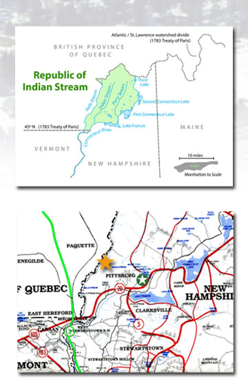
As shown in the accompanying area map, Pittsburg is the northernmost township in NH, bounded by Quebec on the north and west, Vermont on the west, and Maine on the east. It is the largest municipality by area in all of the US, encompassing 360 square miles (300,000 acres) of mountains, timberlands and forest trails and miles of lakes, rivers and streams. This territory was first settled in pre-Revolutionary days, having been sold to speculators [including members of the Meacham, Bedell and Quimby families], by a chief of the Abenaki tribe. The area came to be known as Indian Stream, and the Treaty of Paris (1783) ending the Revolution set the US boundary "at the northwestern most head of the Connecticut River." Because several streams feed into that head, this ambiguous definition resulted in intense squabbling among British and US officials as well as various other claimants as to the exact path of the boundary. The arguments persisted for over 60 years during the late 18th and early 19th centuries. Finally, in 1832, the exasperated residents of this remote wilderness took matters into their own hands and declared themselves the independent Republic of Indian Stream, complete with constitution, bicameral legislature, courts, laws, and a militia. This declaration was ignored by both the US and Canadian authorities until, following a ludicrous event in which members of the Indian Stream Militia invaded Canada to rescue a compatriot who had been arrested by a British sheriff and interred in Canada, the two governments agreed to intervene. While waiting for resolution of the problem, the Indian "Streamers" voted to be annexed by the US. The New Hampshire Militia occupied the area shortly thereafter. In 1836, Britain gave up its claims, and the boundary was established according to the American interpretation of the Treaty of Paris. In 1840 the Republic of Indian Stream was incorporated as the Town of Pittsburg, so named after William Pitt, Prime Minister of the United Kingdom. At the time, the population numbered about 300. Today, the township still remains lightly populated, with the 2006 Census reporting 850 residents or a population density of about 3 people per square mile, which affords tourists and visitors an opportunity to see first-hand an essentially unspoiled wilderness much as it was in colonial times. In addition, site maps and legal documents can be viewed at the Coos County Registry of Deeds. Click on *Search County Records* and follow the directions there. Enter the following site map numbers to reach the Spruce Cone Park Condominium plans: 3098, 3099 and 3100. |
| HOME | BACK | TOP OF PAGE | CONTACT US | PHOTO GALLERY |
| 2087 North Main Street - Pittsburg, NH 03592 Phone: (603) 538-8361 or (800) 538-6361 - Fax: (603) 538-6347 |
||||